The Parish is well represented within the UK listings for scheduled structures:- it has no less than seventeen although, for some of the bridges, renewed scheduling updates may see them removed. Altogether we have three lift bridges, five brick-built bridges, six houses, an old Smithy, a Church and a moated site. (Fenn’s Old Works from Bronington has also been included as part of the Mosses).
Heritage grades:
Grade II: a building of special interest. Approx 92% of all listed buildings are in this category. Grade II*: a particularly important building of more than special interest. Only 6% of all listed buildings fall into this category.
Much of the following information and images have been collated from many sources, all of which are in the public domain. Where it is possible photo credits have been given but, if we have been unable to find /credit the photographer we will be happy to alter our site in accordance with their wishes should they wish to contact us. Where content has been derived from the internet, searches have been undertaken using Google Chrome.
The structures included in the section include:
- Bridge Number 43, Platt Lane (Grade II)
- Roundthorn Bridge (Grade II)
- Moated site at Mossley Well Farm (spelling taken from Heritage Scheduling)(Scheduling)
- ED Cottage, Moss Lane (Grade II)
- Morris’s Bridge (Grade II)
- Roving Bridge House (Grade II)
- Allman’s Bridge (Grade II*)
- Squinch Bridge (Grade II)
- Stark’s Bridge (Grade II*)
- Dobson’s Bridge (Grade II)
- Boodles Bridge (Grade II)
- Squatters Cottage, Waterloo (Grade II)
- The Smithy (Grade II)
- Church of St. Mary (Grade II)
- Yew Tree Cottage (Grade II)
- Higher House, Stanley Green (Grade II)
- Hornspike Road Farmhouse (Grade II)
- Fenn’s Moss Peat processing Plant (Bronnington) (Grade II*)
- Project 6420 Whixall Moss
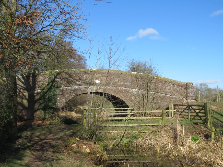
Bridge Number 43, Platt Lane
Heritage Category: Listing Grade: II. List Entry Number: 1237311 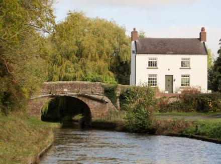
SHROPSHIRE UNION SJ 53 NW CANAL 2/203 Bridge No. 43 – – II Canal bridge.
Circa 1800 on William Jessop’s and Thomas Telford’s Ellesmere Canal. Red brick with some engineering brick patching; coped stone parapet. Single elliptical arch with keybricks, string course, parapet and corner piers. Retains cast-iron plate above arch on north side with bridge number “43” in raised lettering. The section of the former Ellesmere Canal between Welsh Frankton and Tilstock Park on which Bridge No. 43 is situated, was built between 1797 and 1804. The Ellesmere Canal Company amalgamated with the Chester Canal Company in 1813 and became part of the Shropshire Union in 1846.
Ref: Charles Hadfield, Canals of the West Midlands (3rd edn. 1985) pp.177, 331.
Listing NGR: SJ5109336467
Immediately in front of the white house on the right side of the canal was a wharfage used predominantly for unloading of coal. The other side of the bridge on the left side of the canal, near Huxley’s farm buildings, was another wharfage which was used for the loading of extracted peat which was transported elsewhere for use as animal litter, bricketts for burning, and as horticultural supplements.
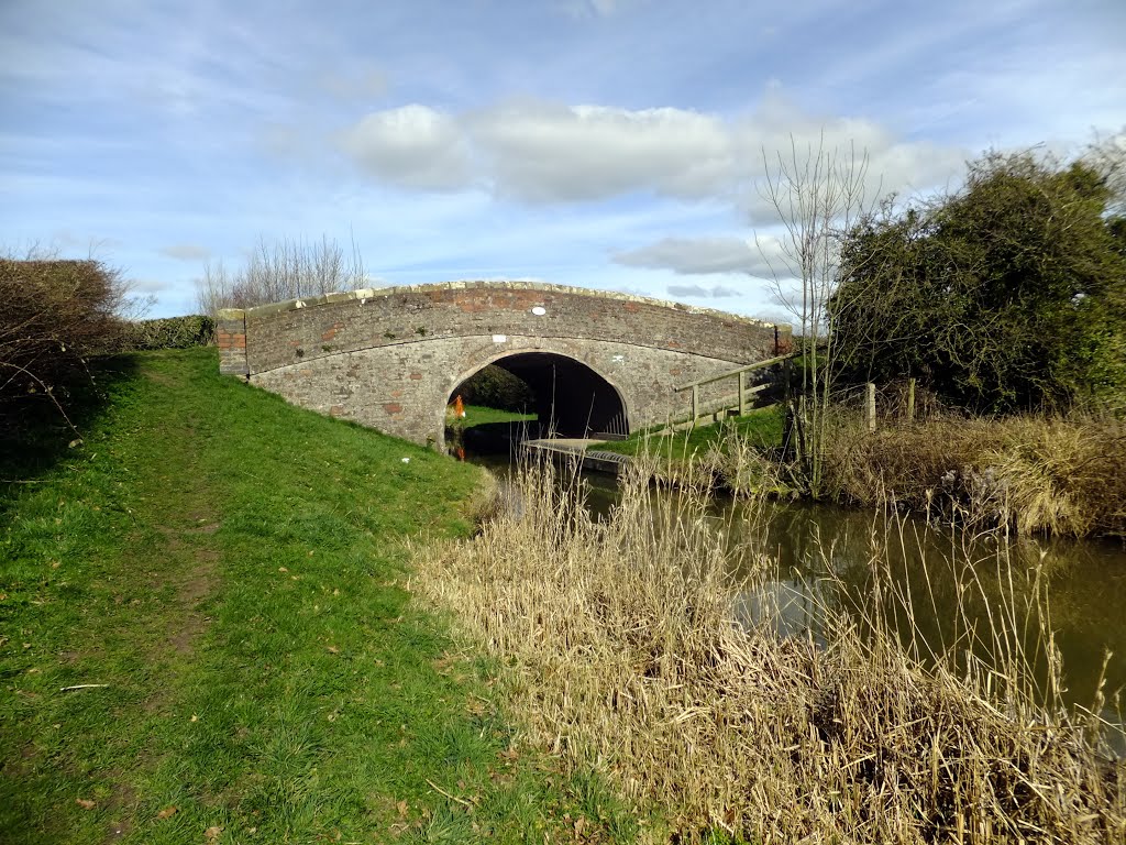
Roundthorn Bridge
Heritage Category: Listing Grade: II List Entry Number: 1264234
SHROPSHIRE UNION SJ 53 NW CANAL 2/204 Roundthorn Brid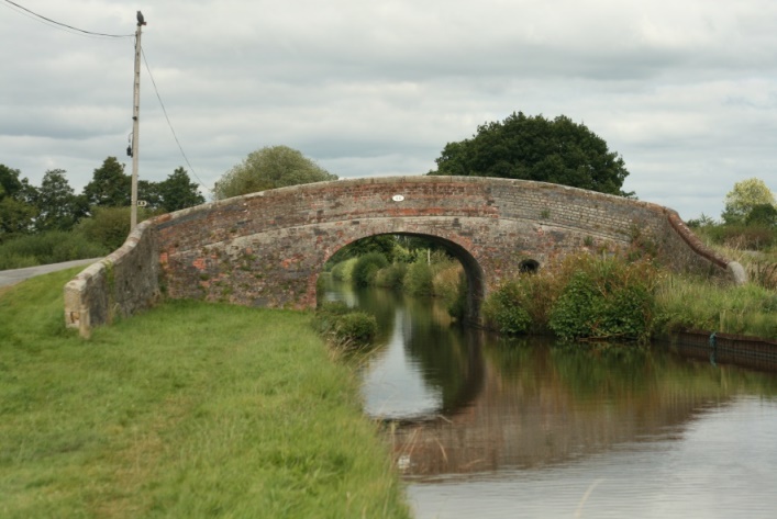 ge – – II Canal roving bridge.
Circa 1800 on William Jessop’s and Thomas Telford’s Ellesmere Canal. Red brick with some engineering brick patching and coped stone parapet; uncoursed rubble to ramped approach on both sides of towpath. Single elliptical arch with keybricks, string course and parapet. The section of the former Ellesmere Canal between Welsh Frankton and Tilstock Park, on which Roundthorn Bridge is situated, was built between 1797 and 1804. The Ellesmere Canal Company amalgamated with the Chester Canal Company in 1813 and became part of the Shropshire Union in 1846.
Ref: Charles Hadfield, Canals of the West Midlands (3rd edn. 1985) pp.177, 331. Listing NGR: SJ5006935705
(This bridge received some renovation to the side brick works in late 2017).
Moated site and cultivation remains
List Entry Number: 1019651 Heritage Category: Scheduling. List Entry Number: 1019651
Location: 310 metres north-west of Mossley Well Farm, Whixall, Shropshire.
Reasons for Designation
Around 6,000 moated sites are known in England. The majority of moated sites served as prestigious aristocratic and feudal lord residences with the provision of a moat intended as a status symbol rather than a practical military defence. The peak period during which moated sites were built was between about 1250 and 1350 and by far the greatest concentration lies in central and eastern parts of England. However, moated sites were built throughout the medieval period, are widely scattered throughout England and exhibit a high level of diversity in their forms and sizes. They form a significant class of medieval monument and are important for the understanding of the distribution of wealth and status in the countryside. Many examples provide conditions favourable to the survival of organic remains.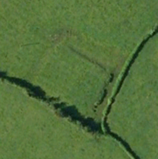
The monument includes the earthwork and buried remains of a medieval moated site and later ridge and furrow cultivation remains north west of Mossley Well Farm. The moated site is situated on a gradual north west facing slope in an area of gently undulating land, about 200m south of the the edge of Whixall Moss. The moat is dry except for the south eastern arm. It defines a rectangular island approximately 25m south west-north east by 30m north west-south east. It would appear that the island was originally about 30sq m with all the moat arms between 8m and 12m wide. The north eastern arm appears to have been widened in modern times. Material excavated from the moat has been used to raise the surface of the island by up to 0.5m above the level of the surrounding land. The field in which the moated site is situated was once in arable cultivation and the remains of narrow post-medieval cultivation strips, aligned north west-south east, cross the moated site partially infilling and slightly altering the profile of the south western and north western moat arms. (Image, cropped, from ©Google Earth).
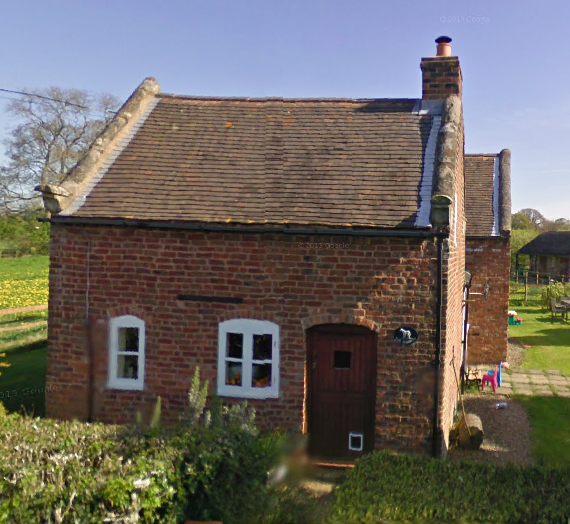
ED cottage, Moss Lane.
Heritage Category: Listing Grade: II List Entry Number: 1237204
MOSS LANE (east SJ 43 NE side) SJ 4964 3505 1/202 Disused cottage.
Cottage, now disused. Late 17th century with later additions and alterations. Timber framed and red brick; corrugated iron replacing thatch roof. 2-cell plan. One storey and gable-lit attic. Framing: square panels, 2 from cill to wall-plate with position of infilled doorway to right. Boarded door to left with 19th century casement to right; contemporary fixed- light window immediately to left of infilled doorway. Integral end stacks.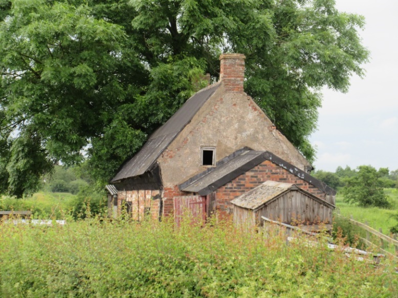
(Sam Dulson used to actually live in this house. In 2017 is was still being used as a shelter for a small flock of domestic sheep).
Listing NGR: SJ4964035050
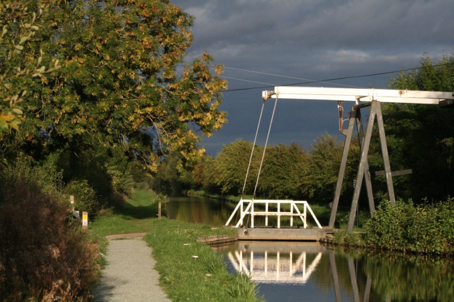
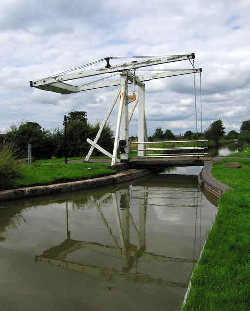
Morris’s Bridge
Heritage Category: Listing Grade: II List Entry Number: 1237314
SHROPSHIRE UNION SJ 43 NE CANAL 1/205 Morris’ Bridge – – II Canal lift bridge.
Probably c.1800 with later repairs and modifications. Wooden bascule bridge operated by counterweight and chain system. The bridge is still in moderate use today for visitors accessing the car-park and footpath onto Whixall Moss.
Listing NGR: SJ4935435394
[Note: Since its upgrading and strengthening to permit lorry and vehicle access to Furber’s Scrap Yard, now closed, the modifications may have been such that the bridge lost its Listed building status].
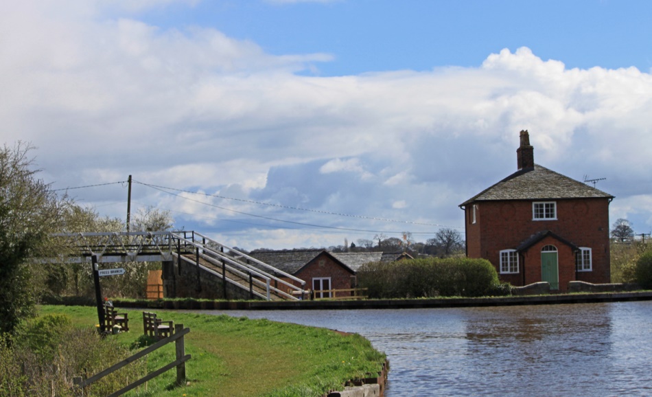
Roving Bridge House
Heritage Category: Listing Grade: II List Entry Number: 1237205
SHROPSHIRE UNION SJ 43 NE CANAL (south side) 1/206 Roving Bridge House.
Toll keeper’s cottage, once a farmhouse, now a private residence. Built circa 1800 on William Jessop’s and Thomas Telford’s Ellesmere Canal. Red brick (of English bond); pyramidal graded slate roof with wide spreading eaves and central red brick stack with ceramic chimney pots. Square plan. 2 storeys to canal side plus semi-basement to rear. Blind roundels to first floor flanking 19th century casement directly below eaves; ground floor has segmental-headed horizontal sliding sash to left and 19th century casement to right of original gabled brick porch with boarded door and semi- circular fanlight. Interior: semi-basement has exposed ceiling joists and 3 round-headed doorways with original plank doors. Situated at the junction between the main line of the former Ellesmere Canal and its Prees branch.
Allman’s Bridge (Edstaston Branch)
Heritage Category: Listing Grade: II* List Entry Number: 1237206
SHROPSHIRE UNION SJ 43 SE CANAL (Edstaston Branch) 5/207 Allman’s Bridge.
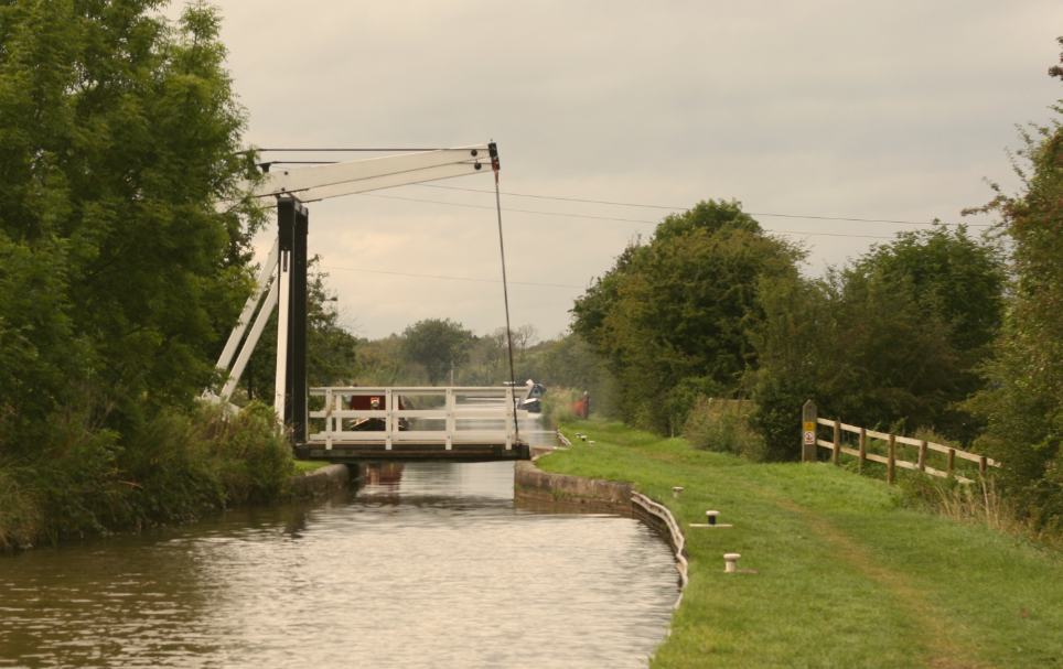
A canal lift bridge, probably c.1800-06, with later repairs on the Prees branch of William Jessop’s and Thomas Telford’s Ellesmere Canal. Wooden bascule bridge operated by counterweight and chain system. The Prees branch was originally intended to reach Prees Higher Heath but by 1806 had only got as far as Quina Brook, near Edstaston, where it was decided to terminate it. Although designed for heavier traffic it now serves mainly walkers for the Shropshire Way, and local ‘Whixall Walks’, as well as the rare vehicle.
Squinch Bridge (Edstaston Branch)
Heritage Category: Listing Grade: II List Entry Number: 1237334
SHROPSHIRE UNION SJ 53 SE CANAL (Edstaston Branch, east side) 5/208 Squinch bridge.
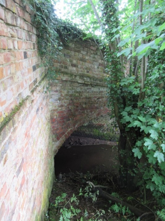
Situated over stream approx. 15m north-east of Allmans Bridge. Built circa 1800-06 over a drainage ditch running under the Prees Branch of William Jessop’s and Thomas Telford’s Ellesmere Canal. Red brick with rebuilt coped parapet and single segmental arch. It is probably associated with the drainage of Whixall Moss, over which the Prees Branch of the Ellesmere Canal was constructed between c.1800 and 1806.
Difficult to find the bridge is best located via the parapet on the right hand side of the lane and peering over.
Starks Bridge (Edstaston Branch)
Heritage Category: Listing Grade: II* List Entry Number: 1244333
SHROPSHIRE UNION SJ 43 SE CANAL 5/10000 Starks Bridge.
A canal lift bridge. Probably circa 1800-6 [with later repairs, the most recent of which in 2017], on the Llangollen [Ellesmere] Canal, Prees branch. A wooden bascule bridge operated by counterweight and chain system. Was closed to vehicular access in 2008 due to its deteriorating condition. Is still in use as a footpath and bridleway.
Back to top of page
Dobson’s Bridge (Edstaston Branch)
Heritage Category: Listing Grade: II List Entry Number: 1237207
 A canal bridge, circa 1800-06 on the Prees branch. Of red brick construction with some engineering brick patching to soffit of arch; coped stone parapet. Single elliptical arch with keybricks, string course, parapet and corner piers. The bridge is still accessible to all vehicular traffic it being the main artery between Whixall and all destinations to the west. This section of the canal between the clay /marl pits (now the marina) back to Roving Bridge,remained in commercial use until c.1940. Now it is used primarily for barges to access the marina and its chandlers.
Back to top of page
Boddles Bridge (Edstaston Branch)
Heritage Category: Listing Grade: II List Entry Number: 1237348
SHROPSHIRE UNION SJ 43 SE CANAL (Edstaston Branch) 5/210 Boodles Bridge.
 A canal bridge, circa 1800-06 on the Prees branch. Red brick with moderate engineering brick patching; coped stone parapet. Single elliptical arch with keybricks, string course, parapet and corner piers. Probably the least known of all of the structures over the canal due to its position towards the end of the ‘terminated-short’ Prees branch. It marks the end of the linear Shropshire Wildlife Trust reserve of the canal which stretches between the bridge and the marina. The canal here supports small numbers of water vole. It is now used only for the passage of cattle from one side of the canal to the other.
Back to top of page
Squatters Cottage, Waterloo
Heritage Category: Listing Grade: II List Entry Number: 1237209
WATERLOO SJ 53 SW 6/213 No. 15 – 7.8.87 – II Squatter’s cottage.
 Late 18th century with minor later additions and alterations. Red brick (Flemish stretcher bond); plain tile roof with coped verges on carved stone kneelers. 2-cell plan. One storey and gable-lit attic with dentilled eaves cornice. Two mid-19th century fixed-light windows with segmental heads to left of segmental-headed boarded door. Integral end stack to right.
An unspoilt example of a late 18th century squatter’s cottage now serving as a private residence. It’s name is probably representative of an even older residence being on this site as the current building could hardly have been built in a day with smoke coming from its chimney by dusk (the definition of a squatters cottage).
Back to top of page
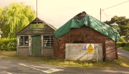
The Smithy
Heritage Category: Listing Grade: II List Entry Number: 1237208
Previously listed as ‘disused but in working order’ it is now no longer maintained as a blacksmiths. Built originally in the mid- to late 19th century it has undergone several alterations and additions, namely two tin and wooden workshops to the rear. Its listed notation reads “of red brick; slate roof with ridge stack to left of centre and truncated end stack to right it is of one storey with dentilled eaves cornice. Fixed-light windows to right, large one with glass replacing 19th century shutters; plank door to left of centre. Position of horse’s entrance to rear with fixed-light window and re-used panelled door replacing original double doors. Interior: retains furnace with hand-operated bellows; anvil and [at the time] complete set of blacksmith’s tools”.
Church of St. Mary
List Entry Number: 1237211 Heritage Category: Listing Grade: II
WHIXALL CP WHITALL SJ 53 SW 6/214 Church of St Mary 28.10.60 – II Parish church.
1867 by G E Street. Red brick (English bond) with sandstone ashlar dressings; slate roofs with ornamental cresting and coped verges. Nave and chancel with full-length north aisle and vestry. Nave: in 4 bays on double- chamfered plinths; plain 2-light windows with plate tracery and shallow leanto porch with pointed arch in west bay. West window of 4 broad lancets with 2 roundels and one quatrefoil above. Lead-covered spirelet with louvred belfry at east end. Lean-to north aisle has 6 broad paired lancets with trefoil heads and similar window of 3 lights to east; eastern part incorporates vestry/organ chamber with shouldered arch to doorway. Chancel: in 2 bays on triple-chamfered plinth has string course and angle buttresses at east end. South side has lancet to west and window with plate tracery to east. East window of 3 lancets with sexfoil above. Interior: brickwork exposed with trussed rafter roofs to nave and chancel, latter boarded. North nave arcade in 4 pointed bays has circular stone piers with moulded plinths and capping. Pointed chancel arch-on corbelled responds.
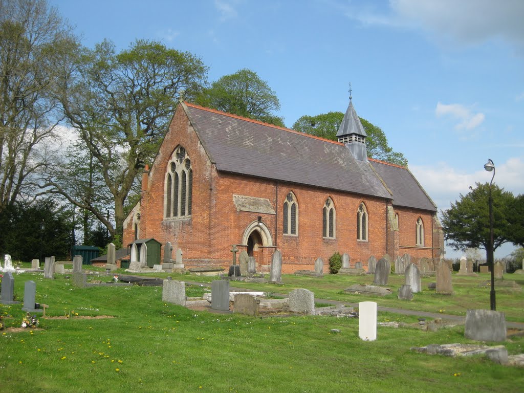 Fittings and furnishings including low stone screen to chancel, altar rails, stone pulpit and early English style, font at west end with clustered columns all by street. Late C18 or early Cl9 benefactors boards on north wall of north aisle and C17 font come from an earlier chapel. Font is hexagonal and dated 1608; ornamented with a scalloped shell, a lion rampant, birds, rosettes and fleur-de-lys; formerly with a Jacobean font cover. Brass plate in chanel records that present church was erected in 1867 “in grateful recognition of the character and services of John Allen, vicar of Prees and Archdeacon of Salop”. Whixall was originally a dependent chapelry of Prees and the site of the previous chapel, which dated to C17, lies approximately a quarter of a mile to the south (N.G.R SJ 516 344). B.O.E. p.318; D. H. S. Cranage, The Churches of Shropshire, Part 8 (1906) p.740.
Listing NGR: SJ5179734861
(See also under Churches)
Back to top of page
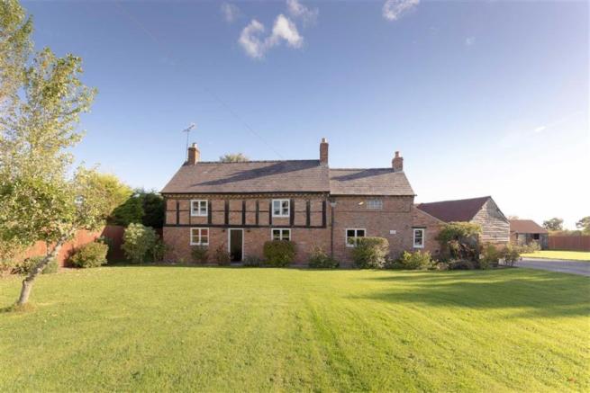
Yew Tree Cottage
List Entry Number: 1237304 Heritage Category: Listing Grade: II
WHIXALL C.P. ABBEYGREEN SJ 53 SW 6/200 Yew Tree Cottage – – II Farmhouse, now house. Early 17th Century, altered and extended late 20th Century. Timber framed with rendered infill; machine tile roof. Original end baffle-entry plan of 3 framed bays extended by one bay to left late 20th Century. One storey and attic. Framing: square and rectangular panels, 3 from cill to wall-plate, with short straight tension braces. Late 20th Century fenestration; latticed casements in panels of framing, one to left and 2 to right of 20th Century gabled porch with half-glazed door; 3 contemporary gabled eaves dormers directly above casements. Infilled segmental-headed doorway to far left. One casement and one dormer to 20th Century addition. Reddish brown stack behind ridge at junction between 17th Century part and 20th Century addition and similar external end stack to right. Interior: inspection not possible at time of resurvey (March 1986) but noted as having timber frame substantially intact including to cross-walls; chamfered ceiling beams. Prominent late 20th Century additions to rear are not of special architectural interest.
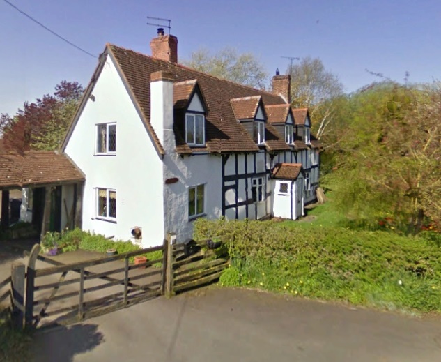
Listing NGR: SJ5066733175
Back to top of page
Higher House, Stanley Green
List Entry Number: 1264144 Heritage Category: Listing Grade: II
WHIXALL C.P. STANLEYGREEN SJ 53 NW 2/212 Higher House – – II Farmhouse, now divided. Early 17th Century, partly rebuilt early to mid- 19th Century with later additions and alterations. Timber framed with painted brick infill and 19th Century red brick cladding or replacement; plain and machine tile roofs. L-plan comprising hall range of 2 wide framed bays with central baffle-entry and 2-bay cross-wing projecting to right; late 17th Century timber framed addition attached to left gable end of hall range. 2 storeys. Framing: cross-wing has square panels, 4 from cill to wall-plate, with short straight tension braces; collar and tie beam truss with part of V-strut visible to rear gable; front gable clad or rebuilt in 19th Century brick with exposed single-purlin ends. Hall range: front wall clad or rebuilt in 19th Century brick but framing survives to back above painted brick plinth; 3 square panels with short straight tension braces.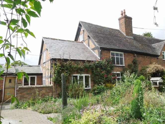 Position of infilled doorway and 2-light mullion windows visible to right of centre. Late 17th Century addition attached to left gable end of hall range has rectangular panels to rear and gable with single-purlin ends but 19th Century red brick cladding or replacement to front. Late 19th Century segmental-headed casements to left and right of central 4-panel door (top panels now glazed) to hall range with casement directly below eaves above left casement and another in gabled half-dormer to right; subsidiary 4-panel door (top panels also glazed) to far right in angle with cross-wing. This has 19th Century segmental-headed casement on each floor. Another 19th Century segmental- headed casement to extension to left of hall range. Cross-wing has integral lateral stack to right and stepped external end stack to rear gable; prominent ridge stack in 2 sections to centre of hall range. 19th Century single-storey gabled brick outbuilding attached to rear gable or cross-wing. Interior: not inspected but likely to be of interest.
Listing NGR: SJ5213935691
Back to top of page
Hornspike Road Farmhouse
List Entry Number: 1264233 Heritage Category: Listing Grade: II
WHIXALL C.P. HORNSPIKE ROAD SJ 43 SE (east side) 5/201 Hornspike Road – Farmhouse – II Farmhouse. 17th Century, partly remodelled and extended late 18th Century with later additions and alterations. Roughcast timber frame on high red brick plinth (mixed bond) with red brick additions; slate roofs. Original house of 3 framed bays, extended by single bay to right and eaves raised late 18th Century. Two storeys with dentilled eaves cornice. Late 19th Century casements on each floor to left and right of central boarded door under gabled hood to 17th Century part; 18th Century addition has cast-iron fixed- light window directly below eaves and two small 20th Century casements to ground floor. Integral end stacks to 17th Century part and to right of 18th Century addition. Two-storey outshut to rear of 17th Century part with back wall rebuilt in 19th Century brick. Interior: left ground-floor room has chamfered cross beam with heavy joists; right ground-floor room of 17th Century part has chamfered spine beam with ogee stops and heavy joists. Straight-flight staircase between two rooms. Timber frame visible beneath wall-paper to first floor, including to cross walls. Plank doors with strap hinges and original floorboards.
Listing NGR: SJ4816634144
Back to top of page
Fenn’s Moss Peat processing plant (Grade II*)
Coflein reference: NPRN 33358 NGR SJ4780 3665. Cadw listed II*
Although situated on the Welsh side of the border most influences affecting the Mosses have nearly always been driven from the English side. Seemingly then the Mosses appear to have been fully ‘adopted’ by the English, irrespective of the national boundary. In keeping with this ‘adoption’ the Fenn’s Old Works are included here (acknowledging that it does not actually reside within the Parish).
Peat extraction has a long history. In medieval times it was used for animal bedding and fuel while during the 1st World War it was again used for animal bedding and fuel, but also as an antiseptic battle dressing. In the late nineteenth century industrial exploitation took over. Cut peat was crushed and sieved, the ‘dust’ (fine granulated peat) used in packing and for cattle feeds, the ‘litter’ (coarse /medium granulated) was used for livestock and poultry bedding as well as for horticultural use, and finally ‘turf blocks’ were still sold as fuel.
The Fenn’s Peat processing works is a grade II* listed structure which is, quite possibly, the only one of its type still standing. The original machinery is still ‘in-situ’ – a hammer mill and crusher, elevators, rotary screens and three balers of two types (two by Webster & Bickerton and one by Shitliffe). Attached is also a National heavy oil engine that used to provide all the power. This too is a rare survivor.
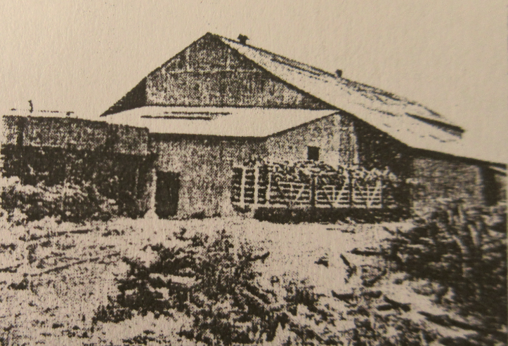
This is a rare photograph of the peat works in its heyday (article from Shropshire Magazine, date unknown). See entry also under ‘Mosses’
Back to top of page
Project 6420 Whixall Moss
 Completed in November 2013 was Stage I of National Heritage’s inventory of sites of ‘Exceptional Waterlogged Heritage’. By virtue of the bog bodies found over the years, with the unconfirmed presence of boats, Whixall Moss was included on this (short) list. The report stated that the site was “currently well managed and well protected through existing natural designations”. Stage 2 of the project, currently underway, there is a requirement to define site boundaries and produce brief statements of significance as a precursor to Exceptional Waterlogged Heritage status.
Back to top of page